Historical Resources
Travelling to Dodona
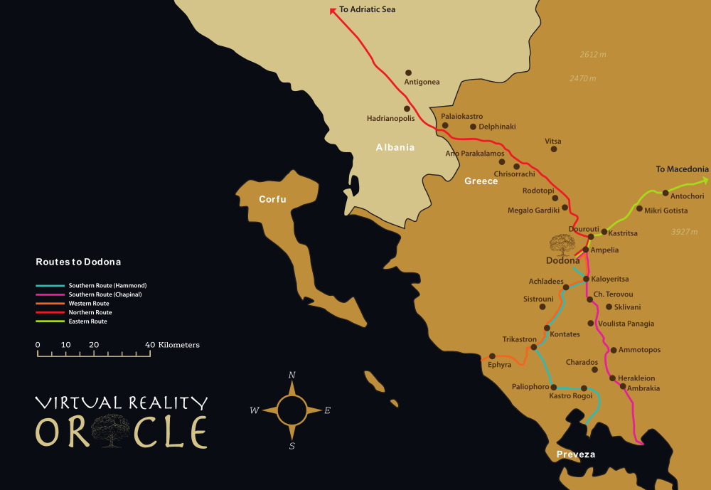
There are various routes that a pilgrim might take to reach the sanctuary of Dodona:
Nigel Hammond describes a number of different routes to the site (Hammond 1997:17-18). He emphasises the following journey as the main route from the south:
`pilgrims from southern Greece on the way to Dodona would come by sea into the Gulf of Arta, sail up the Louros and disembark before or at Bouchetion (Rogoi). They would then follow an easy route up the Xeropotamos valley, cross a low pass into the valley of the upper Acheron, follow its course up to a pass by Variades and descend into the valley of the uppermost Louros. From this point (above Kopane) the pilgrims followed the Sacred Way on the side of a gorge overshadowed by cliff above cliff of Mt Tomaros (Olytsika), crossed the stream by a theogephyra [‘god’s bridge’] or natural bridge of conglomerate rock, and emerged into the small plateau at the head of which the shrine of Zeus of Dodona was situated.'
This is disputed by Heras-Chapinal, who argues that some of the sites have been misidentified. He argues that the likely main route for pilgrims from the south was the other route that Hammond describes. This runs from Ambrakia to Ammotopos, from there to Mt Xerovouni (via Pente Pegadia) to Moulesi, and then a climb from Moulesi to plateau of Ioannina.
From the north, both scholars agree, pilgrims would likely have travelled via the valley of the Aoos river, to the Drinos valley, from which they could travel to Despotikon, cross the Kalamas river via another theogephyra, climb to Zitsa and thus to the Ioannina plateau.
From the north-east, Heras-Chapinal argues, the main route would have used a corridor of passes through the mountainous area, passing Metsovo (Chapinal-Heras 2021).
From the west the route would have started at Ephyra, the mouth of the Acheron river: ‘From there it was possible to follow the river to Kastri Mesapotamou/Pandosia and, after passing to the Xeropotamos valley, to join the western route that went from the south’. This may be the route that Homer had in mind when he described Odysseus travelling to Dodona (Odyssey 14.327)—since the harbour of Ephyra was active in the Mycenean period.
References
- Chapinal-Heras, D. 2021. Experiencing Dodona: The Development of the Epirote Sanctuary from Archaic to Hellenistic Times. Berlin: De Gruyter.
- Hammond, N.G.L. 1997. ‘Physical Features and Historical Geography’ in Epirus: 4000 Years of Greek History and Civilization, edited by M.B. Sakellariou, 12-31. Athens: Ekdotike Athenon S.A.